Taiwan - Strengthening and improvement works for submerged dikes at Nanbin and Huaren
Adaptation Framework : Promote implementation
Adaptation Option : Structural
Issue : Coastal erosion
Core Content : Management policies, offshore submerged breakwaters
Case Characteristics : practical operation
Scale : City/County
Author : Liang Tingyu
View : 2628
Issues and Objectives
The Coastal Management Act was promulgated and implemented on February 4, 2015, with the aim of "maintaining natural systems, ensuring zero loss of natural coastlines, responding to climate change, preventing coastal disasters and environmental damage, protecting and restoring coastal resources, promoting integrated coastal management, and fostering the sustainable development of coastal areas." Following the Coastal Management Act, the Ministry of the Interior formulated a comprehensive coastal management plan to protect, safeguard, utilize, and manage coastal land, which was promulgated and implemented on February 6, 2017. This plan is the highest-level plan for coastal areas, delineating first- and second-level protection zones and protection zones throughout Taiwan. The section from Jiali Village in Xincheng Township to Shuilian Village in Shoufeng Township, Hualien County, has moderate potential for coastal erosion and has been designated as a second-level coastal protection zone, requiring the formulation of a coastal protection plan. Therefore, the Ninth River Management Office of the Water Resources Agency drafted the Hualien Coastal Protection Plan, which integrates coastal disaster adaptation measures for the general seawall environment and facilities under its jurisdiction.
The North Coast, South Coast, and Huaren Coast of Hualien County stretch for approximately 4 kilometers, bordering the Meilun River estuary and Hualien Port to the north, and the Hualien River estuary to the south. Located adjacent to a prime section of Hualien City, it is a key area for flood control. After the completion of the east and west breakwaters of Hualien Port in 1987, changes in the coastal current field and sediment drift characteristics led to significant siltation at the Meilun River estuary, while the South Coast and Huaren Coast south of the North Coast experienced severe erosion and retreat.
Improvement Measures Taken
To ensure the safety of people's lives and property and in response to the increasingly serious coastal erosion, the Jiujiang River Management Bureau began in 1996 to construct 16 offshore breakwaters along the Nanbin and Huaren coastlines to protect the coast and stabilize the beach line. The project was completed in 2003.
In 2018, repairs were carried out on submerged dikes that had been damaged by typhoons and waves. 1,350 30-ton concrete blocks were made and placed (Figure 1) to strengthen and improve one submerged dike in Nanbin and four submerged dikes in Huaren, which were severely damaged, and to restore them to their original function.
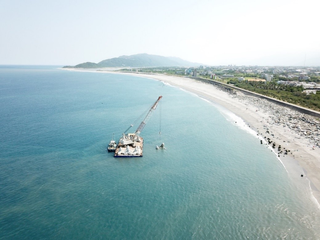
Figure 1. Placement of newly made irregularly shaped concrete blocks. Source: Jiuhe Bureau (reference website 4)
Results
Offshore breakwaters can reduce wave energy and protect the coastline. Due to their porous nature and ability to provide sheltered spaces, they can also be used as artificial reefs. This improvement project won first place in the 9th Excellent Project Award of the Water Resources Agency, Ministry of Economic Affairs.
Since 2004, the Jiuhe Bureau has been continuously monitoring the changes in the beach line of the North and South Binhuaren coastal sections. Coastal topographic monitoring and survey data from 1986 to 2018 (Figure 2) show that the coastline erosion has slowed down and tended to stabilize. The beach line from the South Binhuaren coastline has gradually recovered to about 5 meters, while the beach line of the North Binhua coastline has increased by 6 to 14 meters.
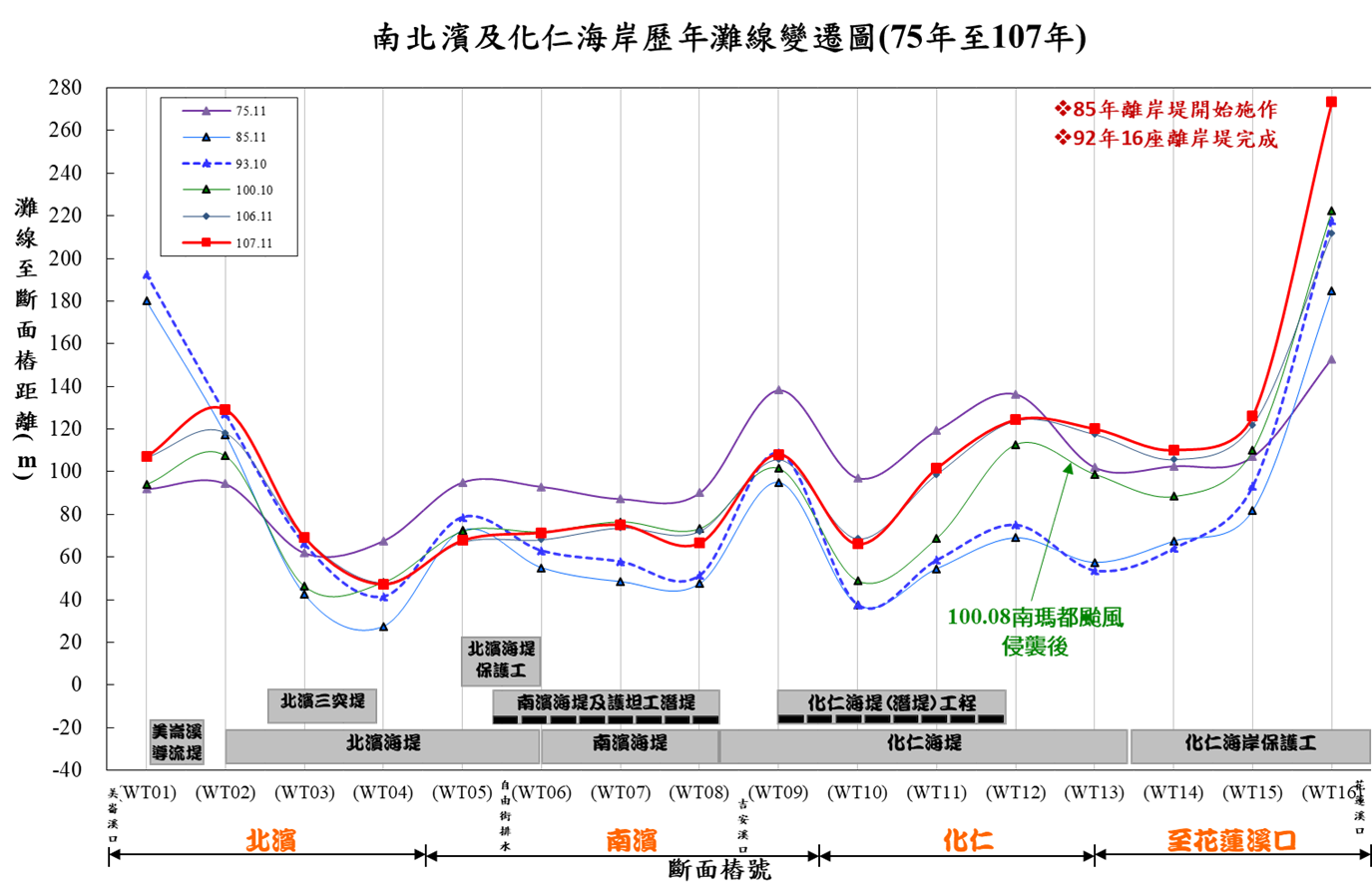
Figure 2. Historical changes in beach line along the North and South Binhe and Huaren coastlines (1986-2018). Source: Jiuhe Bureau (Reference website 2)
The South Coast has been transformed into an ecological coast by the Nine Rivers Bureau, replacing breakwater blocks with natural large rocks (Figure 3), promoting coastal ecological restoration and environmental landscape improvement. The submerged breakwater can be used as an artificial reef, achieving the goal of sustainable development of Hualien's coastal environmental resources.
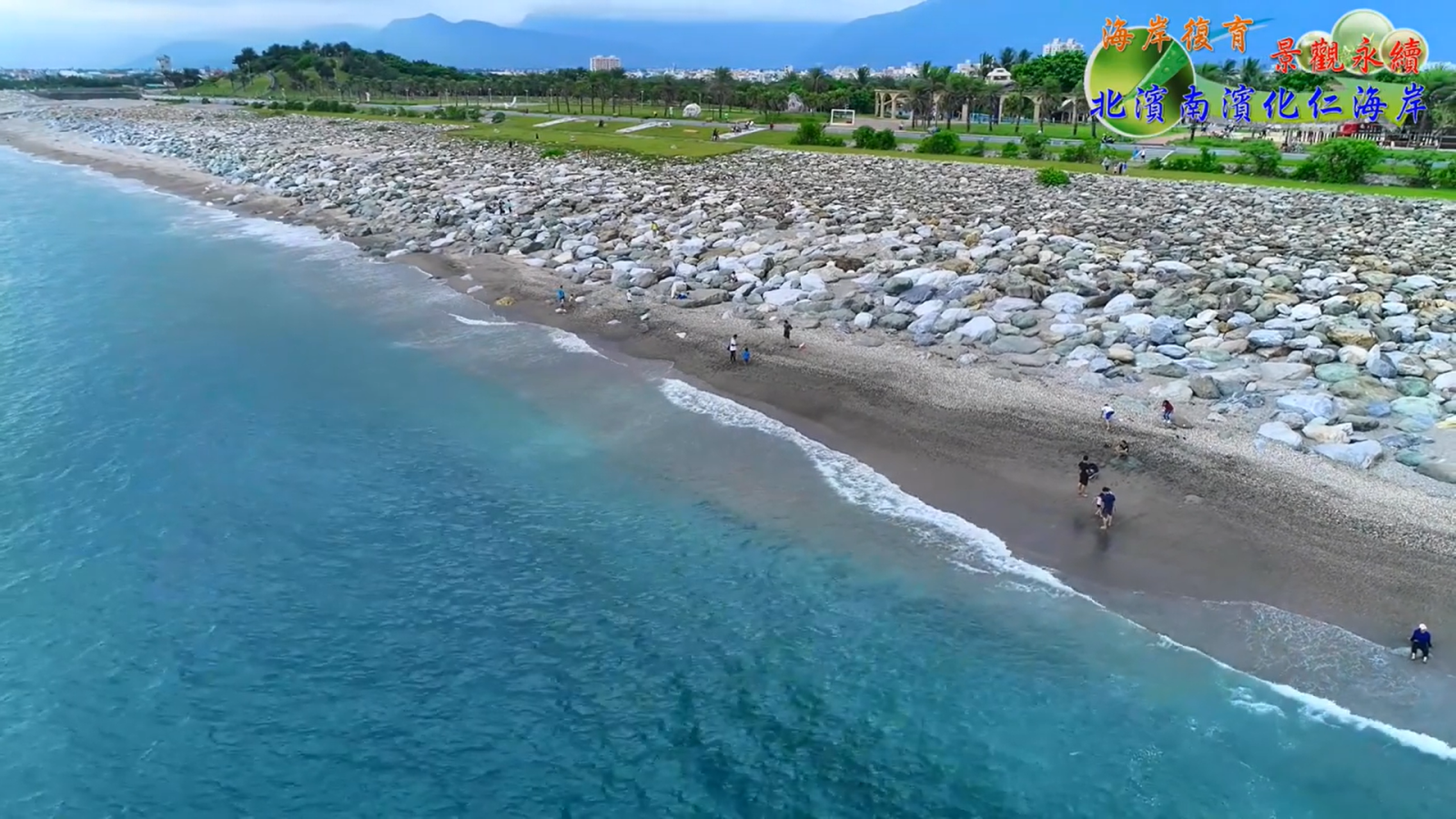
Figure 3. Gentle slope natural pebble paving on the South Coast. Source: Video of the Hualien Coastal Environmental Improvement Project, Nine Rivers Bureau (Reference URL 1)
Reference Websites
- 九河局河你在一起(Facebook),花蓮海岸環境營造改善工程(2020-02-26)。檢自https://www.facebook.com/751431781899213/videos/622457811872923/ (Jul. 7, 2020)
- 經濟部水利署第九河川局網頁,恭賀本局榮獲經濟部水利署第九屆優良工程第一名(南濱及化仁潛堤加強改善工程)(2019-05-08)。檢自https://www.wra09.gov.tw/13110/13134/13217/99873/ (Jul. 7, 2020)。
- 經濟部水利署第九河川局網頁,「花蓮海岸防護計畫規劃」第二階段民眾溝通及參與座談會(2018-03-08)。檢自https://www.wra09.gov.tw/News_Content.aspx?n=14748&s=79122 (Jul. 7, 2020)。
- 水利署電子報,保衛花蓮海岸 第九河川局海事工程整備(2018-09-28)。檢自http://epaper.wra.gov.tw/Article_Detail.aspx?s=232EA7FABDBE5AF6 (Jul. 7, 2020)。
- 經濟部水利署網頁,南濱及化仁潛堤加強改善工程。檢自https://www.wra.gov.tw/News_Content_Table.aspx?n=2806&s=6967 (Jul. 7, 2020)。
- 內政部營建署網頁,海岸管理法(2015-02-04)。檢自https://www.cpami.gov.tw/最新消息/法規公告/18451-海岸管理法.html (Jul. 7, 2020)。