Taiwan - Local flood detention of Youcailiao Drainage in Yunlin County
Adaptation Framework : Promote implementation
Adaptation Option : Structural
Issue : Land subsidence, flooding
Core Content : On-site flood detention, agricultural damage compensation
Case Characteristics : practical operation
Scale : Townships/Communities
Author : Xiao Yihua
View : 3023
Issues and Objectives
Yunlin County is located in the central region of Taiwan. Parts of the county are situated on the Chianan Plain, where the terrain is flat, making it one of Taiwan's major agricultural counties, also known as the "Agricultural Capital." In addition to its flat terrain, the area is located on the southern half of the Zhuoshui River alluvial fan, making it suitable for growing crops. Furthermore, there is extensive aquaculture in the coastal areas, which has led to increased groundwater extraction and subsequent land subsidence. Cumulative subsidence has persisted since 1992, with the overall subsidence center concentrated in Baozhong Township, Tuku Township, Huwei Township, and Yuanzhang Township, as generally shown in Figure 1. Due to the aforementioned reasons, the area faces the threat of flooding whenever typhoons or torrential rains occur, leading to losses for farmers. For example, large-scale flooding disasters due to excessive rainfall occurred during Typhoon Kong-rey in 2013, the 0601 torrential rain in 2017, the 0823 torrential rain in 2018, and the torrential rain from July 31 to August 2 in 2021.
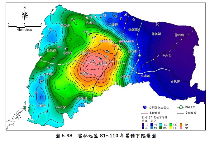
Figure 1. Cumulative Subsidence Map of Yunlin Area from 1992 to 2021 (Image Source: Land Subsidence Prevention Information Website)
Improvement Measures Taken
To resolve the perennial flooding problems in Baozhong Township, a low-lying area in Yunlin County, the Water Resources Agency of the Ministry of Economic Affairs implemented the Youcailiao On-site Water Detention Project in Youcai Village. This project utilizes ecological engineering methods for localized water detention, raising the farmers' land by about 50 cm to 1 meter and storing water without changing the existing land use status. Without expropriating the farmland, farmers can still cultivate their land, retain their farmer insurance eligibility, and the natural features are preserved. Compared to the construction of traditional detention basins, this project has lower costs and a shorter construction period. The subsidy contract includes compensation for crop damage due to water retention, compensation for crop damage due to engineering work, and a water detention incentive payment to encourage farmers to provide land for detention. Overall, this project combines minor structural engineering methods with institutional regulations.
The Youcailiao On-site Water Detention Project is planned for 1,150 hectares, divided into Phase I (614 hectares) and Phase II (536 hectares). This includes raising field ridges, managing sluice gates, and installing simple water gates, all completed in 2022, capable of holding 2.09 million cubic meters of water. The engineering methods are shown in Figure 2, and the project location is shown in Figure 3. For the incentive payments, three different levels (A to C) of water detention incentives were planned, with detailed specifications shown in Table 1.
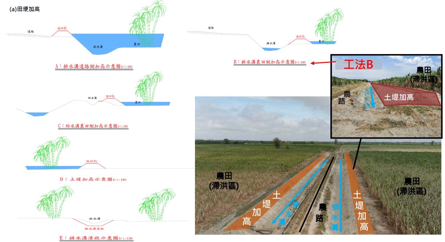
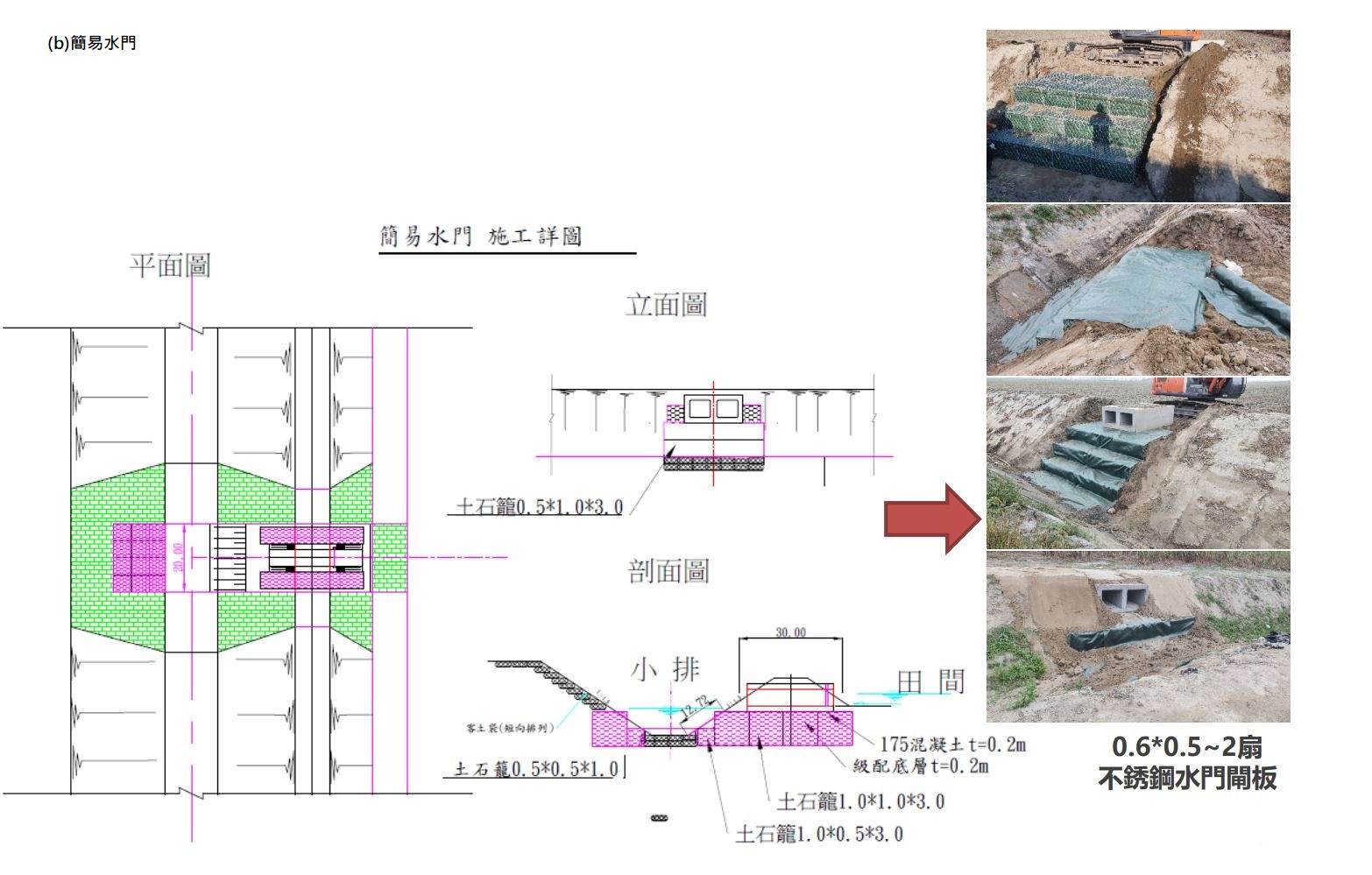
Figure 2. Description of Youcailiao On-site Water Detention Engineering Method (a) Raised Field Ridge (b) Simple Water Gate (Source: The Fifth River Management Office, Water Resources Agency, MOEA)
Table 1. Water Detention Incentive Payments (Source: The Fifth River Management Office, Water Resources Agency, MOEA)
| Level |
Water Detention Depth (cm) |
Water Detention Volume (m3/ha) |
Incentive Payment (Annually) |
| A |
25-50 |
2500-5000 |
NT$10,000/ha |
| B |
50-75 |
5000-7500 |
NT$15,000/ha |
| C |
75 and above |
7500 and above |
NT$20,000/ha |
Results
Prior to implementing the main project, a 2-hectare pilot project was first carried out. The effectiveness of this pilot project in providing localized water detention was demonstrated in a timely manner during the torrential rain event of July 31, 2021, which prevented the village from suffering disaster. Only then was the main project expanded and promoted. It is estimated that this project can reduce the flooded area by approximately 358 hectares, effectively lower the water level at the Tongbei Bridge by about 0.94 meters, and reduce the flow rate by approximately 62 cubic meters per second (cms).
References
Briefing on the Expected Benefits of the Yu-Tainiao Drainage System for Local Flood Detention, Fifth River Management Office, Water Resources Agency, Ministry of Economic Affairs (PDF file)
Reference Websites
地層下陷防災資訊網
http://www.lsprc.ncku.edu.tw/zh-tw/trend.php?action=view&id=18
民視新聞網
https://www.ftvnews.com.tw/news/detail/2023429C14M1
經濟部水利署-第0469期電子報
https://epaper.wra.gov.tw/Article_Detail.aspx?s=7339&n=30177
Attachments
- 有才寮在地滯洪簡報.pdf