Taiwan - Relationship between groundwater resource development and landslides in mountainous areas
Adaptation Framework : Promote implementation
Adaptation Option :
Issue : Impacts of groundwater development on landslides
Core Content : Establishment of a correlation model
Case Characteristics : academic research
Scale : City/County
Author : Zhu Fangyi
View : 1859
Issues and Objectives
Discussions on slope disaster prevention often focus on slope instability caused by rainfall infiltration, with less consideration given to the benefits of increased slope stability due to precipitation. However, rainfall infiltration raises the groundwater level, reducing rock shear strength and exacerbating slope sliding potential; it also impacts water supply in mountainous areas during wet and dry seasons. Under the influence of climate change, heavy rainfall from extreme events may exacerbate landslides; changes in rainfall patterns make wet and dry seasons more pronounced, further straining water supply.
Therefore, this study proposes a win-win strategy that combines the benefits of slope disaster prevention with the effective development of groundwater resources. Taking Gaoshi Village in Mudan Township, Pingtung County as the study area, the Gaoshi landslide site had previously experienced landslides. After the Morakot earthquake in 2009, the sixth and seventh neighboring slopes experienced further landslides and collapses due to rainfall infiltration, resulting in damage such as erosion of residential foundations, loss of land, and cracks in houses and retaining walls.
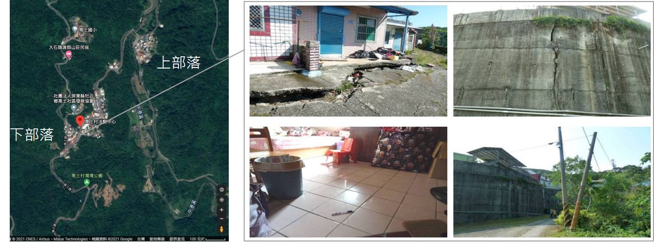
The sixth and seventh neighboring houses on the slope suffered damage such as foundation erosion, land loss, and cracks in houses and retaining walls.
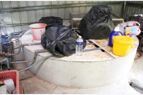
There are cases of people using private wells.
Improvement Measures Taken
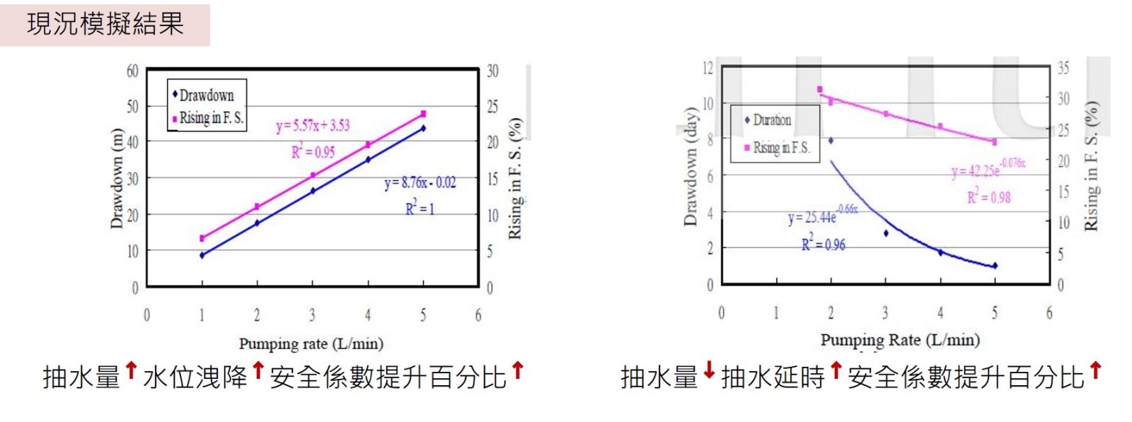
A hydrogeological model was established through on-site investigation, geological drilling, hydrogeological surveys, and monitoring. Groundwater seepage analysis and slope stability analysis were used to explore the correlation between pumping volume, pumping delay, and sliding surface stability (safety factor) at landslide sites. The model simulated the water level drop and its safety factor at different pumping volumes, as well as the required pumping delay and its safety factor at different pumping volumes, and attempted to establish the correlation between these factors, serving as a reference for local water resource development and slope disaster prevention.
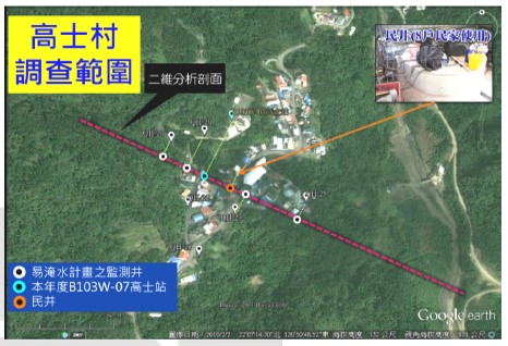
Drilling layout and analysis profile location
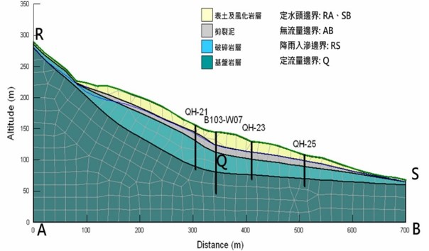
Hydrogeological Concept Model of Gaoshi Collapse Site
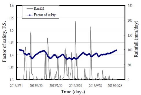
Simulation results of the safety factor of the sliding surface at constant time
Results
Groundwater extraction in mountainous areas effectively improves slope stability, and the relevant assessment procedures can be applied to different regions. Models can also be built according to the characteristics of different areas. Simulation results can provide mountain residents with a basis for local water resource development and disaster risk assessment.
Evaluation results
Glossary
Climate change risk assessment: Using effective assessment tools to understand the medium- and long-term impacts of climate change on various sectors, and to propose corresponding adaptation strategies and actions to reduce the risks brought about by climate change.
Case type:
Structural and physical options: engineering techniques or reinforcement of existing structures, integrated technology development
Social options: learning and exchanging disaster knowledge in the community, and developing and applying early warning information.
Institutional options: Establishing institutions at the economic, policy, and legal levels
References
Luo Hongjie, Xu Shimeng, and Xu Senyan (2016) Research on the effect of groundwater resource development in mountainous areas on improving disaster prevention on slopes, Zhongxing Engineering, pp. 35-44.
Reference Websites
Attachments
- 130035.pdf