Taiwan - Research on risk assessment and governance strategies for sediment management in watersheds
Adaptation Framework : Future risks,Current situation risks,Integrated decision making
Adaptation Option : Institutional,Ecological,Structural
Issue : Sediment disasters caused by extreme rainfall
Core Content : Risk assessment and governance strategies
Case Characteristics : academic research
Scale : City/County
Author : Hsu Yu-cheng
View : 1756
Issues and Objectives
Taiwan's landscape is mostly mountainous and features a large number of slopes, making it prone to landslide events and corresponding sediment-related disasters. These pose a massive impact on the ecological environment and human residential safety. Traditional mountain disaster prevention engineering is based on historical rainfall data to assess sediment volume, scale, and engineering design standards. Although many studies have been conducted on the potential for sediment-related disasters under climate change, the increasing dynamic variability in the timing and spatial distribution of rainfall, and the rising frequency of extreme rainfall events due to climate change, make it a significant challenge whether existing risk assessments and engineering standards can cope with these impacts.
The main objectives of this case study are threefold:
- To redefine the risk factors and their assessment methods for sediment management within watersheds based on the latest international definitions of disaster risk.
- By compiling years of sediment management strategies and implementation effectiveness, and in response to the sediment risk assessment results under climate change, to determine the triggering timing and risk management goals for the subsequent implementation of adaptation strategies.
- To integrate the previous two points, using a key demonstration watershed as an example, to conduct a trial of sediment risk assessment and dynamic adaptation strategy formulation, in order to establish a complete watershed sediment management strategy that can serve as a reference for future planning of watershed governance in response to the impacts of climate change.
Improvement Measures Taken
This project primarily uses data collection and assessment as its main framework (Figure 1). Through data collection and assessment, the Hualien-Fuyuan Stream watershed in the Taiwan area was selected as the demonstration area. The process involved collecting relevant data and defining disaster problems, clarifying the definition of "risk," and constructing a risk assessment procedure (Figure 2). Subsequently, a risk assessment for watershed sediment management was established and trialed using the "Rainfall-Runoff Model" and the "Hydraulic-Sediment Transport Model" (Figure 3). After that, the established risk assessment method was used to create assessments and risk maps under climate change (using estimated data from the IPCC AR5 Atmospheric-Ocean General Circulation Model at 5 km resolution, specifically adopting the GCM model "CESM1-CAM5"). This ultimately allows for the formulation of dynamic adaptation strategies in response to climate change impacts through risk assessment (Figure 4).
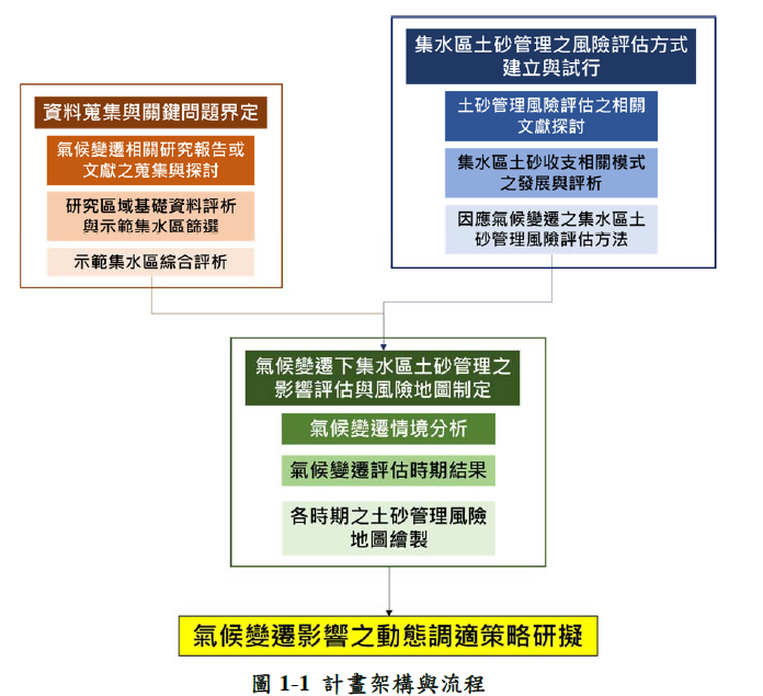
Figure 1. Case Project Framework and Flowchart (Image Source: Reference Link 1)
Figure 2. Risk Assessment Procedure (Image Source: Reference Link 1)
Figure 3. Parameter Analysis Flowchart for Watershed Sediment Management Model (Image Source: Reference Link 1)
Figure 4. Analysis Method for Current and Future Sediment Problems under Climate Change (Image Source: Reference Link 1)
Results
This case study compared relevant domestic and international research to propose a risk assessment equation: Risk = Hazard × Vulnerability × Exposure. The researchers formulated corresponding risk calculation methods specifically for sediment-related disaster types (Figure 5).
Figure 5. Risk Assessment Equation (Image Source: Reference Link 1)
Using the Rainfall-Runoff Model and the Hydraulic-Sediment Transport Model, the researchers simulated sediment transport in a section of the demonstration area's river and assessed the risk under different climate change scenarios. Figure 6 shows the results of the vulnerability factor analysis: red indicates sedimentation (deposition), blue indicates scouring (erosion); a higher positive value represents higher sedimentation vulnerability, and a lower negative value represents higher scouring vulnerability. Figure 7 shows the results of the exposure factor analysis: values approaching 1 indicate smaller available space for scour/deposition, suggesting a higher degree of danger. Figure 8 presents the risk analysis results obtained from the risk assessment: red indicates high sedimentation risk, and blue indicates high scouring risk.
Figure 6. Vulnerability Factor Analysis Results (Image Source: Reference Link 1)
Figure 7. Exposure Factor Analysis Results (Image Source: Reference Link 1)
Figure 8. Risk Analysis Results (Image Source: Reference Link 1)
The researchers further compared domestic and international adaptation options and their applicable scenarios, and evaluated and formulated watershed governance goals and countermeasures, categorized into short-term, medium-term, and long-term adaptation strategies (Figure 9): Short-term measures primarily focus on stabilizing the streambed and implementing stream and slope rehabilitation engineering (check dams, revetments/retaining walls); medium-term measures aim to prevent large amounts of sediment from moving downstream by conducting source-area soil and water conservation engineering, landslide stabilization, and vegetation restoration; long-term measures focus on reducing environmental impact and implementing ecological conservation, such as reducing the volume of concrete structures and implementing land use control measures.
Figure 9. Formulation of Climate Change Adaptation Strategies (Image Source: Reference Link 1)
In conclusion, this case study successfully simulated and established a standard for river sediment risk assessment, which aids in formulating subsequent adaptation strategies with greater practical and economic value. When facing a 50-year frequency flood, scouring around structures in the river channel and downstream of bridges, as well as sediment deposition, is projected to increase significantly. The study suggests mitigating scouring by lowering the height of dam bodies or adjusting their openings, installing transverse structures, and using flow-regulating works, and planning dredging projects for segments with sediment deposition.
References
Fan, Zhengcheng (2019). Risk assessment and dynamic adaptation strategies for soil and sand management in catchment areas under climate change. Innovative research project. National Taiwan University. Nantou County: Rural Development and Soil and Water Conservation Agency, Ministry of Agriculture.
Reference Websites
- https://tech.ardswc.gov.tw/api/File/1242