Taiwan - Sand dune restoration at Chin-Tsao-Lun Coast, Tainan
Adaptation Framework : Promote implementation
Adaptation Option : Ecological,Structural
Issue : Coastal erosion and flooding
Core Content : Environmental restoration
Case Characteristics : practical operation
Scale : Townships/Communities
Author : Liang Tingyu
View : 2153
Issues and Objectives
The Qingcaolun coastline in Tainan, located between the Zengwen River estuary and the Luermen River estuary, stretches approximately 5 kilometers. It can be divided from north to south according to the type of seawall structure: a concrete steep-slope seawall section (northern section), a pebble gentle-slope seawall section (middle section), and a natural sand dune coastline section (southern section). The erosion and sedimentation changes along the Qingcaolun coastline are mainly influenced by the Zengwen River and marine meteorological conditions (waves, currents, etc.). In recent years, the coastal topography has shown a trend of erosion in the northern section and stability in the southern section. Currently, there are sand dunes 2-3 meters high with vegetation cover, and behind them are windbreaks and an animal sanctuary. There are only huts nearby, no residents, and unless there is an urgent need for protection, there should be no immediate danger.
The uplift of natural beaches can be estimated using the wave uplift map in the Shore Protection Manual, which shows the wave uplift height over a 50-year cycle. The maximum uplift height of the Qingcaolun coastline can reach about 3.5 meters, and the seawater will overflow the existing sand dunes and flood the windbreak forest.
Improvement Measures Taken
Lin Zongyi and others selected a small section of natural sand dunes on the southern coast of Qingcaolun in Tainan and conducted a sand dune reconstruction experiment between 2006 and 2007, marking Taiwan's first coastal artificial sand dune reconstruction experiment. The experiment was planned in four groups: artificial vegetation (with/without trellises), natural vegetation, artificial sand accumulation (naturally exposed/covered with trellises), and sand accumulation with fencing. Changes in dune profile, surface sand particle size, and vegetation density were monitored in each sample area to evaluate the efficiency of dune construction and to develop the optimal scheme for local dune reconstruction and vegetation restoration. The results showed that artificial sand accumulation, supplemented by the placement of discarded oyster sheds and bamboo frames on the surface, immediately increased dune height, assisted in sand accumulation, and also helped restore natural vegetation, rapidly stabilizing the artificial dunes.

Figure 1. Four experimental sample areas at Qingcaolun. Source: Lin Zongyi et al., 2007 (Reference 1)
Short-term goal: To build fences to block sand and combine them with vegetation to improve the environmental landscape. Long-term goal: To construct artificial sand dunes.
The height and area of coastal sand dunes are increased artificially using driftwood, oyster shells, or silt dredged from the Luermen Creek as construction materials. The elevation of the dune crest is based on upstream rise, estimated according to the 50-year wave upstream rise cycle, reaching a maximum of approximately 3.5 meters, which serves as the elevation for dune backfilling. The dune surface is then combined with regional vegetation restoration to create green dunes that protect the coastline and the windbreak forest area behind the dunes.
Results
Advantages of dune restoration:
- Dunes serve to prevent flooding and wave damage, and protect the coastline.
- Compared to conventional rigid engineering structures, it not only saves on construction and maintenance costs, but also has a positive impact on the coastal ecological environment and coastal landscape development.
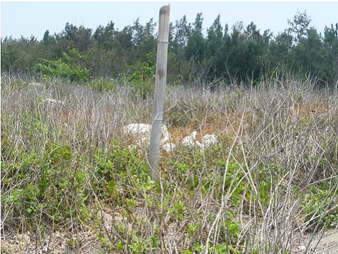
Figure 2. Artificial sand dune sample area at Qingcaolun, 2006–2007 (photographed in April 2011). Good vegetation cover and intact dune structure are evident. Source: Lin Zongyi et al., 2011 (Reference 4).
In the past five years, the 0-meter isobath of the southern section of the Qingcaolun coastline has advanced by about 20 to 30 meters (Sixth River Management Office, Water Resources Agency, 2009), showing a seasonal dynamic and stable change.
If only beach safety is considered, the southern section of the Qingcaolun coastline is relatively stable and safe. Appropriate management of the sand dunes' ecology can not only strengthen their natural defense capabilities but also further enhance their ecological and landscape value, providing the public with a high-quality leisure and tourism environment and an ecological education park.
References
- Lin, Tsung-Yi; Chiang, Wen-Pin; Huang, Hsiang-Yu; Liu, Ching-Yi; Huang, Chia-Lung (2007). Field Experiment on Sand Dune Reconstruction on the Coast of Qingcaolun, Tainan. Proceedings of the 29th Symposium on Marine Engineering, pp. 839-844.
- Huang, Hsiang-Yu; Liu, J.Y.; Zhu, Z.C.; & Xie, J.Z. (2006). A Study on Overall Environmental Restoration Strategies for the Qingcaolun Coast. Proceedings of the 28th Symposium on Marine Engineering, pp. 669-674.
- Liu, Ching-Yi; Chen, Chih-Yuan; Chiu, Yu-Wen; Huang, Hsiang-Yu; Wen, Chin-Ting; Tu, Li-Fu; Chen, Chi-Lin; Chiang, Wen-Pin; Cheng, Fei-Chi (2009). Research on Coastal Ecological Engineering Methods - A Study on Ecological Seawalls (3/3). Special Research Report of the Sixth River Management Office, Water Resources Agency, Ministry of Economic Affairs (Unified Number GPN: 1009804039). Kaohsiung County: Sixth River Management Office, Water Resources Agency, Ministry of Economic Affairs.
- Lin, Zongyi; Liu, Jingyi; Huang, Xiangyu (2011). Field experiment on artificial restoration of coastal sand dunes. Proceedings of the 33rd Symposium on Marine Engineering, pp. 459-464.
Reference Websites