Taiwan - Integrated adaptation for flood-prone areas of Guangcai Wetland, Linbian, Pingtung
Adaptation Framework : Promote implementation
Adaptation Option : Structural,Behavioral
Issue : Frequent flooding threats
Core Content : Improvement of infrastructure and green energy
Case Characteristics : practical operation
Scale : Townships/Communities
Author : Xiao Yihua
View : 5960
Issues and Objectives
Linbian Township, with an elevation of only 3 meters, is located at the mouth of the Linbian River in the southwestern coastal plain of Pingtung County. The terrain is tropical plain, with the soil primarily composed of sandy loam and a small portion of clay. The coastal area is dotted with ponds and lakes, and the terrain slopes gently from northeast to southwest. Agriculture and aquaculture are the main industries. Major agricultural products include wax apples, areca nuts, and coconuts, with the "black pearl" wax apple being the most abundant. Due to its coastal location, aquaculture is highly developed, but excessive groundwater extraction has caused severe land subsidence. This area has long been affected by land subsidence, with about one-third of the land below sea level, resulting in frequent floods and seawater intrusion. Furthermore, the flat terrain slows water flow and hinders drainage. As such, this area faces disasters such as seawater intrusion, soil salinization, and floods, directly impacting local residents and industries.
In 2009, Typhoon Morakot severely damaged Linbian Township, causing the Linbian River embankment to breach and the entire township to be flooded, with water remaining for nearly half a month. This major disaster brought greater attention to the problems facing the area, including the collateral effects of excessive groundwater extraction causing land subsidence, as well as poor soil and water conservation. Excessive development of the mountainous areas, indiscriminate logging, littering, and neglect of environmental protection have led to soil erosion and drainage problems. While these issues may not be easily apparent under normal circumstances, the devastation caused by Typhoon Morakot provided the best evidence of these problems. Floods, silt, and driftwood were among the contributing factors, highlighting the crucial role of soil and water conservation and environmental protection efforts by the local people. This underscores the urgent need for a comprehensive urban redevelopment of Linbian Township.
Improvement Measures Taken
Since the devastation caused by Typhoon Morakot, the Pingtung County Government has been promoting the "Light Up Linbian" project around Linbian Station, gradually developing projects such as solar photovoltaic industry, green energy education, land transformation and utilization, and environmental restoration. The aim is to transform the Linbian area into a green energy and low-carbon town. At the same time, in order to improve the infrastructure needed for the transformation of the subsidence area and promote industrial transformation, the county government has simultaneously launched relevant local infrastructure and industrial adjustment projects in the Linbian area, including: water conservation and power generation, promotion of electric buses, microgrid construction, dual certification of seawater aquaculture, reinforcement and heightening of dikes, and groundwater replenishment.
Based on the above foundation, this project proposes to establish the Linbianxi coastal area as a demonstration project for the integrated value-added development of life, production, and ecology in Taiwan's flood-prone coastal areas, and sets the following three major goals as the basis for future promotion:
- Complex approach for flood-prone areas: Based on phased plans, this approach proposes land transformation concepts for flood-prone areas, introducing industries, residential areas, and environmental restoration to continuously promote local transformation.
- Creating a green disaster prevention landscape: Improving public infrastructure with a green disaster prevention mindset and establishing life support systems that can be used when disasters strike.
- Post-disaster reconstruction of fishing village landscape: nurturing local talent, developing industries and transforming the foundation to support human resources after the transformation of town landscape.
.png)
Figure 1. Schematic diagram of the plan. Image source: Reference website 1
Results
This project has brought about new developments in agriculture and fisheries, combining the application of new technologies. Besides functioning as a flood diversion and retention area in the event of heavy rainfall and inadequate drainage, it is also expected to effectively bring other benefits such as tourism and education. For example, local aquaculture expert Huang Songping was invited to participate in phased stocking experiments of various fish species within the Guangcai Wetland, thus making it a natural aquaculture demonstration area and developing new fisheries. From 2013 to 2015, the Guangcai Wetland was equipped with solar photovoltaic modules, wind turbines, and energy storage systems, along with smart meters to collect electricity consumption data, a hydrogen energy storage system (hydrogen production equipment for hydrogen-powered motorcycles), and a smart energy control and management system, forming Taiwan's first smart microgrid operating in a community. The photovoltaic industry has created a new industrial integration model in the forest area, combining public art with solar photovoltaic systems, stilted demonstration houses, and ecological aquaculture to create a natural ecological area for tourism and recreation, implementing environmental education. An aerial photograph of the completed project is shown in Figure 2. However, in response to interviews with residents regarding this plan, they believed that although dredging and flood retention had been improved, the effect of clearing the routes was not good. They suggested that further improvements should be made to the flow of waterways or the water passage sections of bridges to prevent situations where water still cannot be discharged.
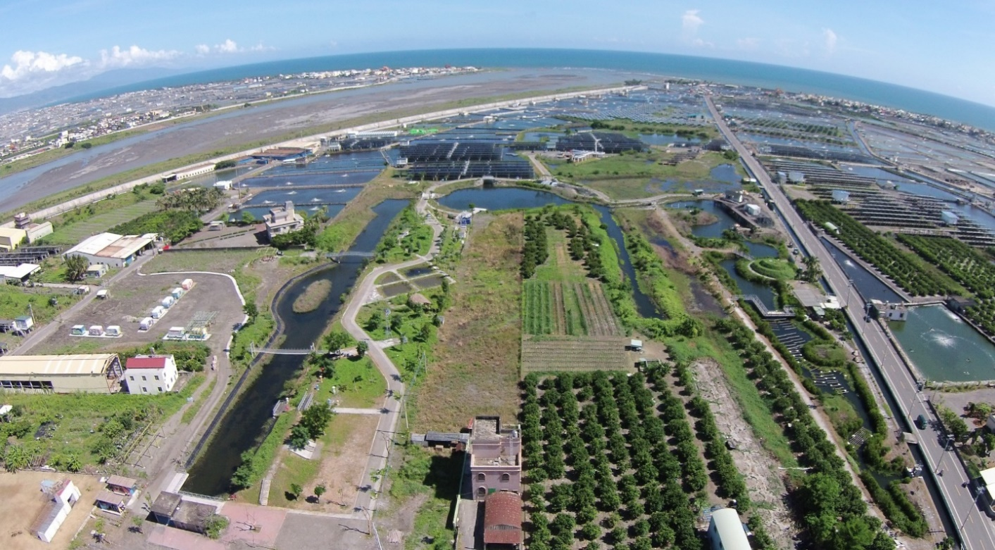
Figure 2. Sunlit wetland after restoration (Image source: Reference URL 2)
Reference Websites