Taiwan - Construction of the Xinwen Flood Detention Basin, Budai Township, Chiayi County
Adaptation Framework : Promote implementation
Adaptation Option : Structural
Issue : Frequent flooding threats
Core Content : Construction of flood detention facilities
Case Characteristics : practical operation
Scale : Townships/Communities
Author : Xiao Yihua
View : 3902
Issues and Objectives
Xinwen area is located between the Longgong River drainage main and the Bazhang River in Budai Township, Chiayi County. Although the area is surrounded by numerous drainage channels and is located inside Provincial Highway 61, some distance from the coastline, thus avoiding the risk of seawater intrusion, many of these drainage channels are tidal sections, resulting in high water levels and poor drainage. During floods or heavy rains coinciding with high tide, these channels often overflow and cause disasters. Furthermore, in coastal areas like Budai in Chiayi, severe land subsidence due to factors such as over-extraction of groundwater is the most important cause of perennial flooding, and monitoring well water level surveys indicate that the subsidence is extending inwards.
Improvement Measures Taken
To address the long-standing flooding problem in the Budai Xinwen area caused by land subsidence, the county government secured priority for implementation of an 8-year, NT$80 billion flood control plan. In 2009, the 76-hectare Xinwen Retention Basin was completed, significantly raising the flood protection standard for the settlement from less than a year's recurrence interval to 25 years without overflow, ensuring that the surrounding 700 hectares will no longer be flooded. The proposed drainage improvement project layout for the Xinwen area is shown in Figure 1. The Xinwen Retention Basin is divided into north and south sections by County Road 163, with a total area of approximately 76 hectares. It also includes pumping facilities and sedimentation basins. The Xinwen Retention Basin was completed in 2009. Due to the local topography and elevation, the water stored in the southern retention pond is not easily drained by gravity or pumped into the nearby Bazhang Creek. Therefore, a culvert was installed between the north and south ponds for connection. The stored water is finally discharged into the Longgong Creek drainage system from the northern retention pond, effectively protecting the area from flooding. The location of the Xinwen retention pond and the on-site photo are shown in Figure 2.
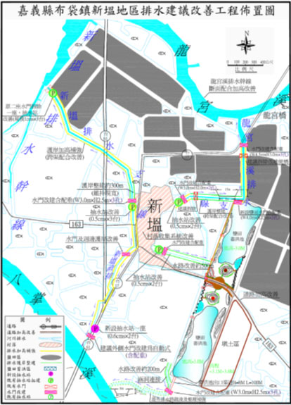
Figure 1. Layout plan of the proposed drainage improvement project in Xinwen area. Image source: Reference URL 1
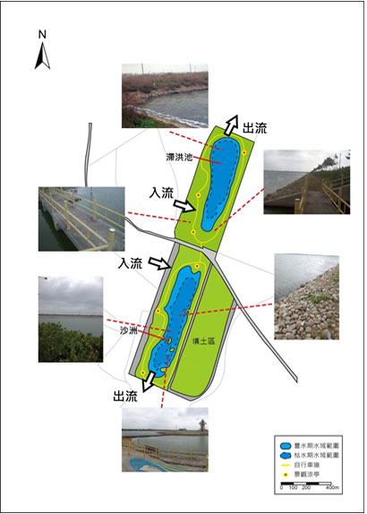
Figure 2. Location of Xinwen Flood Detention Basin and on-site photos. Image source: Reference URL 1
Results
In the drainage systems of Aogu and Longgongxi, the area was originally low-lying with a gentle slope, resulting in poor drainage conditions. Over the years, land subsidence and a relatively high water level have exacerbated the drainage problems. After the renovation of retention ponds and pumping stations, typhoons brought torrential rains, significantly reducing the flooded area, duration, and average depth; some areas even experienced no flooding at all. Figure 3 shows a comparison of the Xinwen retention pond before and after its renovation.
.PNG)
Figure 3. Comparison of Xinwen Flood Detention Basin before and after renovation (Image source: Fifth River Management Bureau, Water Resources Agency, Ministry of Economic Affairs)
Reference Websites
- Electronic newsletter from the Water Resources Agency, Ministry of Economic Affairs.http://epaper.wra.gov.tw/Article_Detail.aspx?s=F9FD3DC52181AD2E。
- Chiayi County Government News.https://www.cyhg.gov.tw/News_Content.aspxn=20C1A3DAF6A74FCE&sms=CA3FB4291106E1D9&s=E6FF28A7DA6B2ED8
- Liberty Times.https://news.ltn.com.tw/news/local/paper/1165274
- Good news from Taiwan.https://news.housefun.com.tw/news/article/1470034738.html