Taiwan - Identification of large-scale landslide potential areas
Adaptation Framework : Promote implementation
Adaptation Option :
Issue : Intense rainfall increases landslide risk
Core Content : Improvement of landslide potential areas
Case Characteristics : practical operation
Scale : City/County
Author : Wu Tingye
View : 3021
Issues and Objectives
Statistics show that since 2000, there have been 11 extreme rainfall events triggered by typhoons, resulting in an increase of 21,069 hectares in landslide area. Besides widespread landslides within catchment areas, large-scale landslides caused by these events have resulted in significant damage to important facilities, settlements, and roads within those catchment areas. According to relevant research, under the influence of rainfall due to climate change, landslides are expected to increase in the future, threatening hillside environments. Therefore, to take proactive measures, it is necessary to understand the potential locations and extent of large-scale landslides.
Improvement Measures Taken
First, a definition of a large-scale landslide was compiled and established, defined as an area with a landslide area exceeding 10 hectares, an earthwork volume of 100,000 cubic meters, or a landslide depth exceeding 10 meters, and exhibiting micro-topographical features of large-scale landslide damage on the slope. High-precision LiDAR data and aerial photographs were used for topographic interpretation, and areas exhibiting structures such as primary landslide cliffs, secondary landslide cliffs, crown landslide cliffs, crown fissures, reverse slopes, and gullies were selected based on literature.
Results
The main effects can be divided into the following points:
- For areas with the potential for large-scale collapses, further monitoring and data collection will be conducted to serve as a basis for understanding the mechanisms and conditions of large-scale collapses and for establishing warning thresholds in the future.
- The Geological Survey of the Ministry of Economic Affairs, the Soil and Water Conservation Bureau of the Council of Agriculture, and the Forestry Bureau have conducted map and data interpretations. Currently, 3,763 large-scale landslides have been identified, with a total landslide area of 1,178 square kilometers. Among them, 106 landslides will affect the safety of 96 settlements. Monitoring and treatment have been carried out on the more critical areas, while settlement relocation has been adopted for areas that cannot be treated by engineering methods.
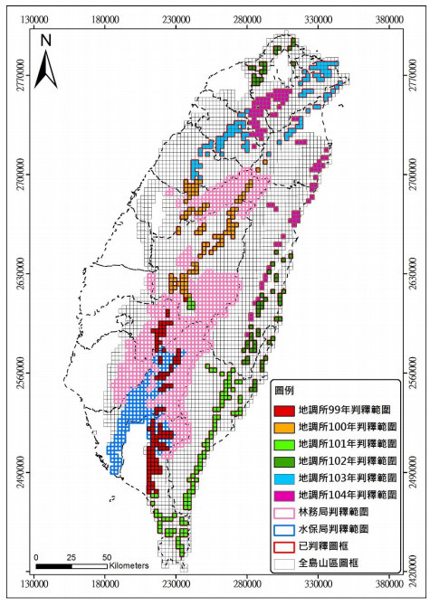
Figure: Interpretation by the Central Geological Survey (2010-2015) of areas with large-scale landslides.
Glossary
Climate change risk assessment: Using effective assessment tools to understand the medium- and long-term impacts of climate change on various sectors, and to propose corresponding adaptation strategies and actions to reduce the risks brought about by climate change.
Case type:
Structural and physical options: engineering techniques or reinforcement of existing structures, integrated technology development
社會性選項:社區災害知識的學習與交流、警戒資訊的研發與運用
Institutional options: Establishing institutions at the economic, policy, and legal levels
References
- Potential large-scale collapse (document)
- National Science and Technology Center for Disaster Prevention and Relief, 2015, Action Plan for the Prevention and Control of Large-Scale Landslides.
- Soil and Water Conservation Bureau, Council of Agriculture, Executive Yuan, 2013, 102nd year report on the potential for large-scale landslides on hillsides along the Gaoping River.
- Soil and Water Conservation Bureau, Council of Agriculture, Executive Yuan, 2014, 103rd year of Morakot disaster: Risk assessment and simplified observation system for potential large-scale landslide areas in central and eastern Taiwan.
- In 2014, the Soil and Water Conservation Bureau of the Council of Agriculture, Executive Yuan, conducted a feasibility assessment of potential locations for large-scale landslides in the Morakot typhoon disaster area using radar imagery.
- Soil and Water Conservation Bureau, Council of Agriculture, Executive Yuan, 2015, 104th year of the Morakot disaster: Risk assessment of potential large-scale landslide areas and establishment of a simplified observation system.
- Soil and Water Conservation Bureau, Council of Agriculture, Executive Yuan, 2016, 2016, Risk Assessment and Establishment of a Simplified Observation System for Potential Large-Scale Landslide Areas in Non-Morakot Disaster Areas.
- Central Geological Survey, Ministry of Economic Affairs, 2012, Analysis Report on Potential Large-Scale Landslide Areas in the Morakot Disaster Area, Results of the 2010 National Land Conservation Geological Sensitive Area Survey and Analysis Project.
- Central Geological Survey, Ministry of Economic Affairs, 2013, Analysis Report on Potential Large-Scale Landslide Areas in the Central Morakot Disaster Area, Results of the 2011 National Land Conservation Geological Sensitive Area Survey and Analysis Project.
- Central Geological Survey, Ministry of Economic Affairs, 2013, Analysis Report on Potential Large-Scale Landslide Areas in the Morakot East Disaster Area, Results of the 2012 National Land Conservation Geological Sensitive Area Survey and Analysis Project.
- Central Geological Survey, Ministry of Economic Affairs, 2014, Analysis Report on Potential Large-Scale Landslide Areas in Non-Morakot Disaster Areas (New Taipei City, Taoyuan County, Hualien County), Results of the 2013 National Land Conservation Geological Sensitive Area Survey and Analysis Project.
Reference Websites