Taiwan - Improvement measures at the Xinhua Forest Farm under climate change to enhance ecosystem services in the Hutoupi Watershed
Adaptation Framework : Promote implementation
Adaptation Option : Ecological,Structural
Issue : Flood inundation
Core Content : Integrated flood management measures
Case Characteristics : practical operation
Scale : City/County
Author : Xu Dawei
View : 1476
Issues and Objectives
The Hutoupi area of the Sinhua Forest belongs to the Yanshui River Basin, with geological conditions of mudstone and sandstone. Historically, it was mainly affected by typhoons and earthquakes. However, in recent years, the heavy rainfall brought by climate change has led to sediment accumulation and an excessively narrow river width, causing floods to overflow. For example, the overflow of the stream due to a tropical depression on August 23, 2018, caused riverbank collapse, stream bank erosion, and road interruption, affecting the safety of roads and farmlands. The turbid water quality also impacted the local ecosystem. The impact of human development is gradually intensifying under climate change, and the area may not be able to withstand the expanded flood damage in the next hundred years.
Using the Flo-2D Rainfall-Runoff Model, the 50-year frequency maximum one-day rainfall was processed using the SCS method to calculate the rainfall pattern distribution and rainfall loss, yielding the flow hydrograph for the river section as the basis for the 2D hydraulic simulation (Figure 1). A numerical model was established under the Q50 condition combined with a 1m x 1m resolution DEM. The simulation results showed that the river section has insufficient flood discharge capacity and lacks flood detention space. The water depth distribution indicates an average deep channel water depth of 4.5 meters, while the high floodplain experiences 1 meter of inundation (Figure 2). This is due to the shallow streambed, narrow channel, and slow flow velocity, which have led to long-term sedimentation. The downstream section, affected by boundary conditions, shows an increased deep channel velocity. Issues such as aging revetments make the banks vulnerable to damage from water shear stress (Figure 3).
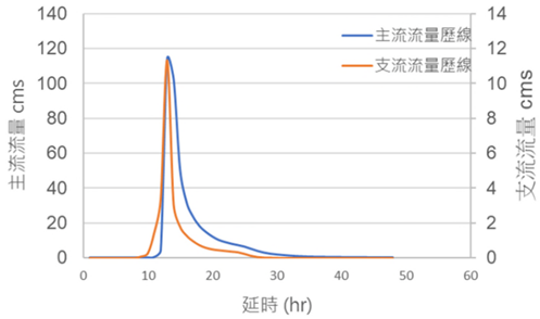
Figure 1. Flo-2D Rainfall-Runoff Prediction of Flow Hydrograph for Main and Tributary Streams under a 50-Year Frequency Flood (Historical Baseline) (Image Source: Reference Literature)
Figure 2. Modeled Flood Water Depth Distribution in the River Channel Before the Current Engineering Work (Image Source: Reference Literature)
Figure 3. Flow Velocity Distribution in the River Channel Before the Current Engineering Work (Image Source: Reference Literature)
Improvement Measures Taken
Implementation Plan: Considering flood control and environmental creation in the Hutoupi area, the plan was based on natural methods. The Council of Agriculture (COA) developed ten measures, including "revitalizing hillside farm ponds," "promoting soil and water conservation on farmland," "enhancing water use from sediment-retention facilities," "strengthening forest restoration," "accelerating landslide restoration," "reinforcing watershed conservation," "strengthening soil and water conservation management," "maximizing forest protection effectiveness," "reinforcing disaster prevention and mitigation for large-scale landslides," and "applying AI and IoT technology."
The remediation strategy adopted for the engineering project, as shown in Figure 4, addresses climate change. Under this framework, the Sinhua Forest Detention and Water Conservation Facility Improvement Project was launched in 2019, including the construction of a pedestrian arch bridge, vertical shafts, catchment wells, spillways, and intercepting ditches. These facilities serve to reduce sediment runoff into the main channel, stabilize water flow, improve water quality, and meet both irrigation and disaster prevention needs. Following this, the remediation project for the Huyuan Stream (Sinhua Forest section) began in 2020, starting with the rehabilitation of the aquatic environment, including widening the river channel and widening the streambed of tributaries to increase flood discharge capacity and slow down flow velocity. Furthermore, ecological check dams and ecological revetments were used. These engineering works aim to provide habitats for aquatic animals, improve water quality, increase flood-carrying capacity, and reduce longitudinal obstructions. In 2021, the second phase of the remediation project addressed insufficient flood discharge sections through solutions such as lowering the height of revetments, pile construction methods, transverse drainage facilities, and ecological check dams.
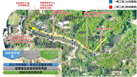
Figure 4. Huyuan Stream Remediation Content (Image Source: Reference Literature)
Results
This case study evaluated the flood discharge capacity of a widened river channel through numerical simulation, as schematically shown in Figure 5. The original river channel width was expanded from 6 meters to approximately 12 meters, and the average streambed width of the tributaries was increased to 5 meters. The simulation results indicate that this solution significantly improves the river channel's flood discharge capacity and detention space. The water depth in the channel is generally between 3 and 4 meters, and the overall water depth is reduced compared to the current condition simulation, thus alleviating the overflow problem (Figure 6). Furthermore, utilizing the open space above the confluence as a wetland detention area can regulate flood volume and reduce backwater phenomena in the tributaries (Figure 7). Figures 8 and 9 show the mobile bed simulation results before and after implementing the widening project. Both before and after implementation, the river channel shows a trend of sedimentation, but the degree of sedimentation is milder after implementing the widening plan, which is inferred to be due to the concentrated flow preventing sediment from easily accumulating. Ultimately, based on the simulation results, this plan can increase the flood discharge capacity from approximately Q2 to Q50, and it can still maintain a flood discharge capacity of approximately Q20 even when considering the flood frequency at the end of the century under climate change.
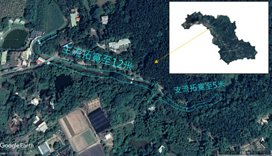
Figure 5. Schematic Diagram of the River Channel Widening Plan (Image Source: Reference Literature)
Figure 6. Flood Water Depth Distribution After the Widening Plan (Image Source: Reference Literature)
Figure 7. Flow Velocity Distribution After the River Channel Widening (Image Source: Reference Literature)
Figure 8. Mobile Bed Simulation Results Before River Channel Widening (Image Source: Reference Literature)
Figure 9. Mobile Bed Sediment Transport Simulation for the River Channel Widening Plan (Image Source: Reference Literature)
References
Chen, Shu-Chun (2022). Improvement Measures for Xinhua Forest Farm under Climate Change to Enhance Ecosystem Services in the Hutoupi Catchment Area. Innovative Research Project. Department of Soil and Water Conservation, National Chung Hsing University. Soil and Water Conservation Bureau, Council of Agriculture, Executive Yuan.
Reference Websites